
Streets submerged in Aberystwyth amid torrential downpours and thunderstorms
10 August 2020, 20:08
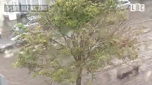
Flash flooding hits west Wales


Parts of west Wales have been left under water after flash flooding and thunderstorms hit the area.
After the weekend heatwave, Aberystwyth was hit by torrential downpours, leaving streets submerged.
Nearly 300 homes in south-west Wales are also without power.
Aberystwyth resident Baz Watkins said it took “about 15 minutes or so” for the storm to “dump enough water to make the drains give up and flood.”
The Met Office has issued weather warnings for thunderstorms for much of the UK over the next few days.
Read more: Tuesday Weather - yellow weather warning for the whole country
Forecasters were preparing for a "worst-case scenario" of up to 150mm this afternoon and this evening in some places - more than twice the 70mm average for the month of August - with heavy rainfall also reported across Devon and Cornwall in the south-west of England.
Read more: People should wear masks during sex and avoid kissing, says sexual health charity
Flooding in Aberystwyth!!! 😯 pic.twitter.com/jEI2Ls0JQ4
— Tom Kendall MYP/ASI (@tomkendall22) August 10, 2020
Read more: Scottish schools reopen with pupils welcomed back
It follows an intense period of very hot weather which saw temperatures reach 34C at Herstmonceux in East Sussex on Sunday, the fourth consecutive day the thermometers passed 30C in the south of England - although there is every chance hot weather will remain, with temperatures of up to 36C possible across the south coast at the beginning part of the week.
Bonnie Diamond, a meteorologist with the Met Office, said there had been some thunderstorms in the south-west of England on Monday morning, while temperatures across the country remain humid, particularly in the south-east of England.
Read more: Coronavirus - 730,000 jobs lost since lockdown began
She said: "Things can change at short notice, and the thunderstorms can come on quite quickly, so people may want to monitor the up-to-date forecasts and our Twitter feed to make sure they don't get caught out in it."
The far north of Scotland is the only part of the UK not currently covered by Monday's broad weather warning.
Northern Ireland is also affected from Monday until Wednesday.
Caroline Douglass, flood duty manager with the Environment Agency, said heavy thunderstorms this week "could lead to surface water and river flooding in some communities" from Monday afternoon into Tuesday morning.
Bit of a flash flood in #Aberystwyth Weatherspoons is closed due to a leaky roof too ⛈⚡️ got to love British weather! #Thunderstorms pic.twitter.com/sIEE8HNxFm
— Shar 😘 (@cymru_79) August 10, 2020
She said: "Isolated flooding is also possible more widely across England today through until Thursday due to further heavy thunderstorms."
The Environment Agency said it would update its flood warnings and alerts as the situation changes, and said those wanting to keep up to date can check on the Gov.uk website, or social media, or through the Floodline service on 0345 988 1188.
The Met Office warned that flash flooding could cause travel disruption and power cuts, but also cautioned about the risks caused by fast flowing or deep floodwater.
It came as a 12-year-old girl died after going missing in the River Leven, near Balloch Bridge, Loch Lomond, in the west of Scotland on Sunday evening. Her body was discovered by emergency services hours later.
In Norfolk, a woman in her 30s died after getting into difficulties in the sea at Waxham on Sunday.
HM Coastguard dealt with 340 incidents across the whole of the UK on Saturday - the highest number of call-outs in a single day for well over four years. There were a further 335 incidents on Sunday.
The current heatwave is nowhere near the infamous summer of 1976, one of the longest in living memory in the UK, when temperatures reached 32C or higher somewhere in the country for 15 consecutive days.