
UK weather: Three days of yellow flood alerts as 'severe thunderstorms' to strike
15 August 2020, 16:30


A weekend washout has lashed Britain, bringing thunderstorms, torrential rain and three days of yellow weather warnings.
Large swathes of southern England are on alert as thundery showers deluge communities that only days ago were baking in 36C heat.
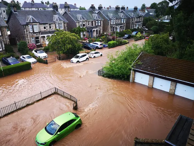
Five flood alerts have also been issued in the Midlands amid warnings of flash flooding that could cause travel disruption.
On Saturday afternoon and evening, England and Wales will experience widespread cloud, scattered heavy showers and some “intense downpours”, the Met Office said.
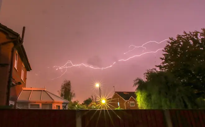
Kent and parts of east London have already seen "severe thunderstorms" on Saturday afternoon, which is set to spread across the UK over the next 48 hours.
Met Office forecaster Greg Dewhurst told LBC News: "We’re looking at some very heavy rainfall, we could see as much as 30mm of rain falling in less than an hour and this could lead to the risk of flooding.
"We could also see some very strong and gusty winds which could bring down some branches, and lighting and hail which could cause some power cuts."
On Sunday, the Met Office said northern areas of Britain will stay dry with sunshine in the west, but rather cloudy in the east. Southern and central parts will enjoy some sunny spells.
But showers and thunderstorms could strike "hit and miss", Mr Dewhurst said.
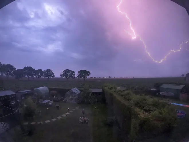
On Monday and Tuesday there is a “risk of severe thunderstorms” in southern England which will only begin subsiding on Wednesday for a less intense bout of rain from the Atlantic.
The Met Office has set three yellow thunderstorm warnings covering the entirety of south-west, south-east, and south-central England for Saturday, with Wales, the Midlands and Greater Manchester also included on Saturday and Sunday.
The alerts indicate that “flooding of homes and businesses could happen quickly, with damage to some buildings from floodwater, lightning strikes, hail or strong winds” and “fast flowing or deep floodwater is possible”, bringing with it disruption to road and rail services.

Met Office chief meteorologist Frank Saunders said: “Up until Monday Thunderstorm warnings cover much of England and Wales, with parts of southern England and South Wales seeing the greatest likelihood of impacts.
“The storms will not affect all areas, but where they happen there will be frequent lightning, gusty winds and intense, heavy downpours with 30 to 40mm of rain possible in less than an hour and, in a few unlucky spots, a small chance of 60 mm falling in a short period.
“With the continuing hot weather, large swathes of the UK continue to be at risk from thunderstorms, and potentially the impacts from heavy rain, into the early part of next week.”
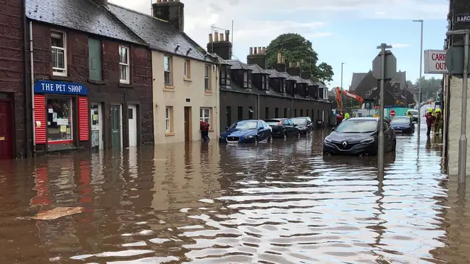
The Environment Agency has also set five flood alerts - meaning “flooding is possible - be prepared” - for the River Blythe in Warwickshire, the rivers Cole and Rea, the Upper Tame and the River Stour and Smestor Brook in the Black Country and south Staffordshire.
Neil Davies, Flood Duty Manager at the Environment Agency, said: “Isolated thunderstorms could bring sudden surface-water and river flooding, which may lead to flooded properties and severe travel disruption in some areas. Further surface water and river flooding is also a possibility until Sunday.
“Environment Agency teams are working hard alongside local authorities to reduce the risk of flooding and keep communities safe, clearing grills and weed screens in areas which may be affected by heavy showers, and are ready to respond and support where needed."
The agency urged people to check their flood risk, sign up for free flood warnings and keep up to date with the latest situation at Gov.uk, call Floodline on 0345 988 1188 or follow @EnvAgency on Twitter for the latest flood updates.